The following table of variables can be used within the XML Gauge system to create colored 2D maps, such as those that appear in GPS or radar systems. Refer to the Creating XML Gauges document for more details on creating XML gauges.
Note that the variables that are new to the Flight Simulator X: Acceleration Expansion Pack, are shown in red.
The 2D map is rendered in the following order. The order cannot be changed, but whether each layer is rendered or not, the colors used, and a number of other features of the map, can be changed through the setting of the various variables.
The compass rose is a separate object in the gauge system, but is drawn on top of the radar screen.
Most of the following variables can only be used by the map gauge itself. Three can be read by other gauges: TagPosition, SelectedVehicle and MapLoading. The first two, TagPosition and SelectedVehicle, can also be set by other gauges.
Variable | Units | Description |
| Priority | Bool | Set to True to draw the map as a priority. |
| Zoom | Float | Range of 80 to 500000 pixels per meter. Default is 5 x 1852 (1852 is meters per nautical mile). |
| PanVertical | Float | Distance to pan vertically in pixels. Negative will pan up. |
| PanHorizontal | Float | Distance to pan right in pixels. Negative will pan left. |
| PanReset | Bool | Set to True to return to the original position prior to any panning. |
| MapLoading | Bool | Set to True if the map is currently being loaded. |
| Latitude | Float | The latitude that is to be the center point of the map (usually the user aircraft, though could for example be an airport tower). |
| Longitude | Float | The longitude of the center point of the map. |
| Heading | Float | The heading (usually of the user aircraft). |
| TrackUp | Bool | Set to True if the map should be drawn with the track of the aircraft facing up. False gives North facing up. |
| CenterX | Float | The X position of the aircraft (usually the user aircraft, but could for example be an airport tower) on the map, in pixels. This is often the actual center of the map, but can be used so that more of the map shows what is in front of the aircraft, and less behind it. |
| CenterY | Float | The Y position of the aircraft on the map, in pixels. |
| UpdateAlways | Bool | Set to True if the map should be updated every frame. Set to False if the map is only to be updated when positions have changed enough. |
| SelectedVehicle | Int | The ID of the selected vehicle. Refer to the ITrafficInfo custom variables described in the Creating XML Gauges document for more details. |
| TagPosition | Int | One of: 0 = UPPERRIGHT 1 = RIGHT 2 = LOWER_RIGHT 3 = BOTTOM 4 = LOWER_LEFT 5 = LEFT 6 = UPPER_LEFT 7 = TOP |
| BackgroundColor | Int | RGB value |
| IceColor | Int | RGB value |
| WaterColor | Int | RGB value |
| Elevation0Color | Int | RGB value |
| Elevation1000Color | Int | RGB value |
| Elevation2000Color | Int | RGB value |
| Elevation3000Color | Int | RGB value |
| Elevation4000Color | Int | RGB value |
| Elevation5000Color | Int | RGB value |
| Elevation6000Color | Int | RGB value |
| Elevation7000Color | Int | RGB value |
| Elevation8000Color | Int | RGB value |
| Elevation9000Color | Int | RGB value |
| Elevation10000Color | Int | RGB value |
| Elevation11000Color | Int | RGB value |
| Elevation12000Color | Int | RGB value |
| Elevation13000Color | Int | RGB value |
| Elevation14000Color | Int | RGB value |
| Elevation15000Color | Int | RGB value |
| Elevation16000Color | Int | RGB value |
| Elevation17000Color | Int | RGB value |
| TerrainShadow | Bool | Set to True if terrain shadows are to be rendered |
| LayerTerrain | Bool | Set to True if this layer is to be rendered |
| LayerBorders | Bool | Set to True if this layer is to be rendered |
| LayerGridLines | Bool | Set to True if this layer is to be rendered |
| LayerAirports | Bool | Set to True if this layer is to be rendered |
| LayerVORs | Bool | Set to True if this layer is to be rendered |
| LayerILSs | Bool | Set to True if this layer is to be rendered |
| LayerNDBs | Bool | Set to True if this layer is to be rendered |
| LayerIntersections | Bool | Set to True if this layer is to be rendered |
| LayerAirspaces | Bool | Set to True if this layer is to be rendered |
| LayerApproach | Bool | Set to True if this layer is to be rendered |
| LayerFlightPlan | Bool | Set to True if this layer is to be rendered |
| LayerVehicles | Bool | Set to True if this layer is to be rendered |
| LayerAirways | Bool | Set to True if this layer is to be rendered |
| LayerRangeRings | Bool | Set to True if this layer is to be rendered |
| LayerRacePoints | Bool | Set to True if this layer is to be rendered |
| DetailLayerTerrain | Int | -1 = Default 0 = Draw nothing 1 = Water only 3 = In color |
| DetailLayerBorders | Int | -1 = Default 0 = Draw nothing 1 = Geopol boundary |
| DetailLayerGridLines | Int | -1 = Default 0 = Draw nothing |
| DetailLayerAirports | Int | -1 = Default 0 = Draw nothing 1 = Dot 2 = Circle 3 = Circle runways 4 = Block runways 5 = Runways |
| DetailLayerVORs | Int | -1 = Default 0 = Draw nothing 1 = Dot 2 = Symbol |
| DetailLayerILSs | Int | -1 = Default 0 = Draw nothing 1 = ILS |
| DetailLayerNDBs | Int | -1 = Default 0 = Draw nothing |
| DetailLayerIntersections | Int | -1 = Default 0 = Draw nothing 1 = Waypoint dot 2 = Waypoint symbol |
| DetailLayerAirspaces | Int | -1 = Default 0 = Draw nothing |
| DetailLayerApproach | Int | -1 = Default 0 = Draw nothing 1 = Approach 2 = Missed 3 = Arrow Head |
| DetailLayerFlightPlan | Int | -1 = Default 0 = Draw nothing 1 = Solid line 2 = Dashed line |
| DetailLayerVehicles | Int | -1 = Default 0 = Draw nothing 1 = ATC symbol 2 = TCAS symbol 3 = Realistic symbol |
| DetailLayerAirways | Int | -1 = Default 0 = Draw nothing 1 = Thin lines 2 = Thick lines |
| DetailLayerRangeRings | Int | -1 = Default 0 = Draw nothing |
| DetailLayerRacePoints | Int | -1 = Default 0 = Draw nothing |
| TextDetailLayerTerrain | Int | -1 = Default 0 = Draw nothing |
| TextDetailLayerBorders | Int | -1 = Default 0 = Draw nothing |
| TextDetailLayerGridLines | Int | -1 = Default 0 = Draw nothing |
| TextDetailLayerAirports | Int | -1 = Default 0 = Draw nothing 1 = ICAO 2 = Name 3 = Name and elevation 4 = Name, elevation and frequencies 5 = Runways |
| TextDetailLayerVORs | Int | -1 = Default 0 = Draw nothing 1 = ID 2 = ID frequency 3 = ID Morse |
| TextDetailLayerILSs | Int | -1 = Default 0 = Draw nothing 1 = ID 2 = ID frequency 3 = ID Morse |
| TextDetailLayerNDBs | Int | -1 = Default 0 = Draw nothing 1 = ID 2 = ID frequency 3 = ID Morse |
| TextDetailLayerIntersections | Int | -1 = Default 0 = Draw nothing 1 = Waypoint ID |
| TextDetailLayerAirspaces | Int | -1 = Default 0 = Draw nothing |
| TextDetailLayerApproach | Int | -1 = Default 0 = Draw nothing |
| TextDetailLayerFlightPlan | Int | -1 = Default 0 = Draw nothing |
| TextDetailLayerVehicles | Int | -1 = Default 0 = Draw nothing 1 = Realistic 2 = Detailed |
| TextDetailLayerAirways | Int | -1 = Default 0 = Draw nothing |
| TextDetailLayerRangeRings | Int | -1 = Default 0 = Draw nothing |
| TextDetailLayerRacePoints | Int | -1 = Default 0 = Draw nothing |
| ObjectDetailLayerTerrain | Int | -1 = Default 0 = Draw nothing |
| ObjectDetailLayerBorders | Int | -1 = Default 0 = Draw nothing 0x1 = Coastline 0x2 = Boundary |
| ObjectDetailLayerGridLines | Int | -1 = Default 0 = Draw nothing |
| ObjectDetailLayerAirports | Int | -1 = Default 0 = Draw nothing 0x1 = Towered 0x2 = Not towered 0x4 = Hard 0x8 = Soft 0x10 = Water 0x20 = Heli 0x40 = Private |
| ObjectDetailLayerVORs | Int | -1 = Default 0 = Draw nothing 0x1 = VOR 0x2 = VOT |
| ObjectDetailLayerILSs | Int | -1 = Default 0 = Draw nothing 0x1 = Cone 0x2 = Line |
| ObjectDetailLayerNDBs | Int | -1 = Default 0 = Draw nothing |
| ObjectDetailLayerIntersections | Int | -1 = Default 0 = Draw nothing |
| ObjectDetailLayerAirspaces | Int | -1 = Default 0 = Draw nothing |
| ObjectDetailLayerApproach | Int | -1 = Default 0 = Draw nothing |
| ObjectDetailLayerFlightPlan | Int | -1 = Default 0 = Draw nothing 0x1 = Enroute 0x2 = Approach 0x4 = Missed approach 0x8 = Waypoints |
| ObjectDetailLayerVehicles | Int | -1 = Default 0 = Draw nothing 0x1 = Track line 0x2 = Ground vehicles 0x4 = Airborne vehicles 0x8 = Racing vehicles |
| ObjectDetailLayerAirways | Int | -1 = Default 0 = Draw nothing 0x1 = Victor 0x2 = Jet |
| ObjectDetailLayerRangeRings | Int | -1 = Default 0 = Draw nothing |
| ObjectDetailLayerRacePoints | Int | -1 = Default 0 = Draw nothing |
| ColorLayerTerrain | Int | RGB value |
| ColorLayerBorders | Int | RGB value |
| ColorLayerGridLines | Int | RGB value |
| ColorLayerAirportsTowered | Int | RGB value |
| ColorLayerAirportsUntowered | Int | RGB value |
| ColorLayerVORs | Int | RGB value |
| ColorLayerILSs | Int | RGB value |
| ColorLayerNDBs | Int | RGB value |
| ColorLayerIntersectionsEnroute | Int | RGB value |
| ColorLayerIntersectionsTerminal | Int | RGB value |
| ColorLayerAirspaces | Int | RGB value |
| ColorLayerApproach | Int | RGB value |
| ColorLayerFlightPlan | Int | RGB value |
| ColorLayerVehicles | Int | RGB value |
| ColorLayerVehiclesSelected | Int | RGB value |
| ColorLayerAirwaysVictor | Int | RGB value |
| ColorLayerAirwaysJet | Int | RGB value |
| ColorLayerRangeRings | Int | RGB value |
| ColorLayerRacePointsGate | Int | RGB value |
| ColorLayerRacePointsPylon | Int | RGB value |
| ColorLayerRacePointsVolume | Int | RGB value |
| TextColorLayerTerrain | Int | RGB value |
| TextColorLayerBorders | Int | RGB value |
| TextColorLayerGridLines | Int | RGB value |
| TextColorLayerAirports | Int | RGB value |
| TextColorLayerVORs | Int | RGB value |
| TextColorLayerILSs | Int | RGB value |
| TextColorLayerNDBs | Int | RGB value |
| TextColorLayerIntersections | Int | RGB value |
| TextColorLayerAirspaces | Int | RGB value |
| TextColorLayerApproach | Int | RGB value |
| TextColorLayerFlightPlan | Int | RGB value |
| TextColorLayerVehicles | Int | RGB value |
| TextColorLayerAirways | Int | RGB value |
| TextColorLayerRacePoints | Int | RGB value |
| FlightPlanLineWidth | Float | Width in pixels. |
| ActiveColorLayerFlightPlan | Int | RGB value |
| PastColorLayerFlightPlan | Int | RGB value |
| LayerApproachAirport | String | ICAO of approach airport. |
| LayerApproachApproach | Int | Index into list of available approaches. |
| LayerApproachTransition | Int | Index into list of available transitions. |
| LayerApproachLeg | Int | Index into list of available legs. |
| LayerApproachLineWidth | Int | Line width in pixels. |
| LayerApproachLineColor | Int | RGB value |
| LayerApproachLineActiveColor | Int | RGB value |
Variable | Units | Description |
| Heading | Float | The heading of the compass. |
| CenterX | Float | The X position of the center of the compass on the map. |
| CenterY | Float | The Y position of the center of the compass on the map. |
| Radius | Float | Radius of the compass in pixels. |
| Color | Int | RGB value of the compass lines and text. |
| BackgroundColor | Int | RGB value. The default, if no color is set, is transparent (so an underlying map will be visible). |
| LineWidth | Float | Compass line width in pixels. |
| Font | String | The font to use for the compass labels. If no font is specified "Arial" is the default. |
| FontSize | Float | Font size for compass labels. |
| BigFontSize | Float | See LabelAllTicks. |
| FullCircle | Bool | Set to True to ensure compass rose is a full circle. False indicates that an arc will be rendered. |
| LabelAllTicks | Bool | Set to True to ensure a label on every tick mark (every 10 degrees). False indicates that labels should be every 30 degrees, and the main four compass points are marked with letters ("N","S","E","W") rendered in the BigFontSize. |
| Force3Digits | Bool | Set to True to force three digits per compass label (see the example image below). |
The view an example map, navigate to the C:\Program Files\Microsoft Games\Microsoft Flight Simulator X\Gauges\radar.cab folder, right click the radarscreen.xml file, and extract it. Refer to the following notes when examining the code:
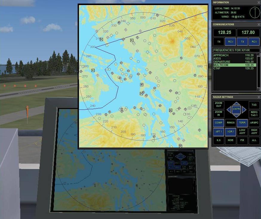
To view the radar screen in the simulation take the role of a Tower Controller in a multi-player session. The image below shows the radar screen. Note the Radar Settings gauge has communicated to the radar screen, through the use of local variables, that a compass rose should be shown, along with airports, VORs, and terrain. The blue line is a national boundary.
 |